French River – Hwy. 69 (south of Sudbury; north of Parry Sound)
French River – What you can see and Envision
View of Canada’s Natural and Cultural Heritage
by Back Roads Bill
Whether you have a fear of heights or not this view is worth it, so walk out on to the bridge and have a look.
 It is what you can’t see below you and can only envision is the value of this vantage point. One of the longest and highest snowmobile bridges in the world affords more than a vista it represents most of our natural and cultural heritage. Crossing the river on Highway 69 the 158 metre long and 40 metre high bridge provides a majestic view of one of Canada’s most historic rivers, it is affectionately known as “The French.”
Steve Hayward is a long-time resident of nearby Byng Inlet and one of the original producers of SnoTrax Television. “This location really made for a special snowmobile program,” said Mr. Hayward. “It is truly an epic view; it represents Canada’s highway of heritage values.” The French flows through a landscape that remains largely as it was when the first Europeans explored it more than four hundred years ago.
In the Beginning
It is difficult to appreciate this abstract timeline. You will see the steep rock walls covered in ice and snow, a rugged representation of Cambrian Shield rock which dates to 900 to 1600 million years ago – some of the oldest rock on Earth. Time and processes that are abstract to us. It is one of the best examples of a glaciated Canadian Shield river environment. Recent glaciation helped create the waterway which became so important to so many people.
In the beginning it was our First Peoples, who used the system of Nastawgan (water trails) to live and trade. Unique rock paintings,  Native place names and archaeological sites along the corridor indicate that The French once served as a major water transportation route used by Shield Archaic and Algonkian native peoples. The Amerindian network was well established before the colonists arrived. It demonstrates the significance of waterways as Indian travel routes before European contact. The French River flows from the southwest end of Lake Nipissing, 195 m above sea level, 110 km, to the northeast shores of Georgian Bay, 177 m above sea level.
The river was the main water Highway to the west in Canada from 1600 to the mid 1800’s. It was part of the easiest east-west routes to the center of North America. The Mississippi River was too long and Hudson and James Bays were most often clogged with ice. The Ojibway Indian name for the river is Wemitigoj-Sibi . The early French explorers gave the river the name la Riviere des Francais. The Champlain Trail, which will be celebrated in 2015, commemorates the explorer’s 400th anniversary. From the time of Étienne Brûlé, the first known European to descend The French, it was a portal to the interior and north-west. For explorers, missionaries and fur-traders alike, it formed a vital link in the voyageur’s highway which ultimately stretched 3,000 miles toward the Pacific and western Artic. On reaching the upper Great Lakes, travel routes branched off in several directions, but for considerably more than half of Canada’s historical period much of the traffic to and from the west went by way of The French. As the name implies, it was the road by which the first traders from settlements on the St. Lawrence River entered the vast domain of Indian tribes who hunted the beaver they sought. They revealed this convenient short-cut to Lake Huron. Ojibwa Indians named the “French River” because the river brought to their land French missionaries and explorers. This impressive list is a sampling of a “who’s who” as you watch for our Canadian legends paddle downstream. The missionary Récollet and Jesuit Fathers came to live with the Huron Indians between 1629 and 1649, and then by the explorers Jean Nicollet, Pierre Radisson, des Groseillers (co-founder of the Hudson Bay Company) and La Verendrye.
European traders transported furs from western and central Canada to the eastern trading centers and continued to develop the French River as a fur trade route throughout the 18th and early 19th centuries. Explorers Alexander Mackenzie, Simon Fraser and David Thompson used this important waterway route too. At this location you would have seen brigades of birch bark craft, up to thirty-six feet long and carrying three tons, pass by regularly, going west in the spring and returning to Montreal in late summer and autumn.
Logs and Ships
Can you see the logs and the shanty men? Lumbermen turned their attention to the north shore of Lake Huron and Georgian Bay beginning about 1870, when dwindling supplies of pine in eastern Ontario and an active demand for lumber in the American west combined to make attractive the timber which could be extracted from rivers entering from the north to the east. Logging Villages grew up along the area including, the French River Village a thriving saw mill community near the river’s mouth on Georgian Bay.
 If history would have had its way you would have a good view of ships the length of two football fields crossing right underneath you laden with grain from the prairies. This vision at one time almost became a reality.
The proposed Georgian Bay Ship Canal was promoted as a project with the magnitude of a Panama Canal. This waterway would have allowed Great Lake freighters to travel directly from Lake Huron to Montreal. As early as 1837, pre Confederation, the Family Compact members of the Assembly of Upper Canada ordered a survey of the possible route. The War of 1812 was still fresh in the minds of the politicians and an inland waterway would skirt American influence. Canada’s first Prime Minister, Sir John A. Macdonald, recognized the potential of the project: “The Ottawa Ship Canal and the Pacific Railroad must be constructed and no voice should be raised against the great national work which would open the western states and the colonies to the seaboard.” The railways won out though.
French River Provincial Park, was designated a Heritage Park in 1985 in recognition of its “historic, natural, and recreational values.” The French became the first Canadian Heritage River, of 38 to date, in 1986; the first such designation reflecting the significance of the waterway. It is because of the rugged nature of the Canadian Shield country surrounding this river, large parts of this river remain relatively untouched and it is now a popular location for recreational canoeing, kayaking, fishing and boating.
Have a Look
Although you will have to wait until next spring to visit the award-winning French River Visitor Centre’s “Voices of the River” exhibit,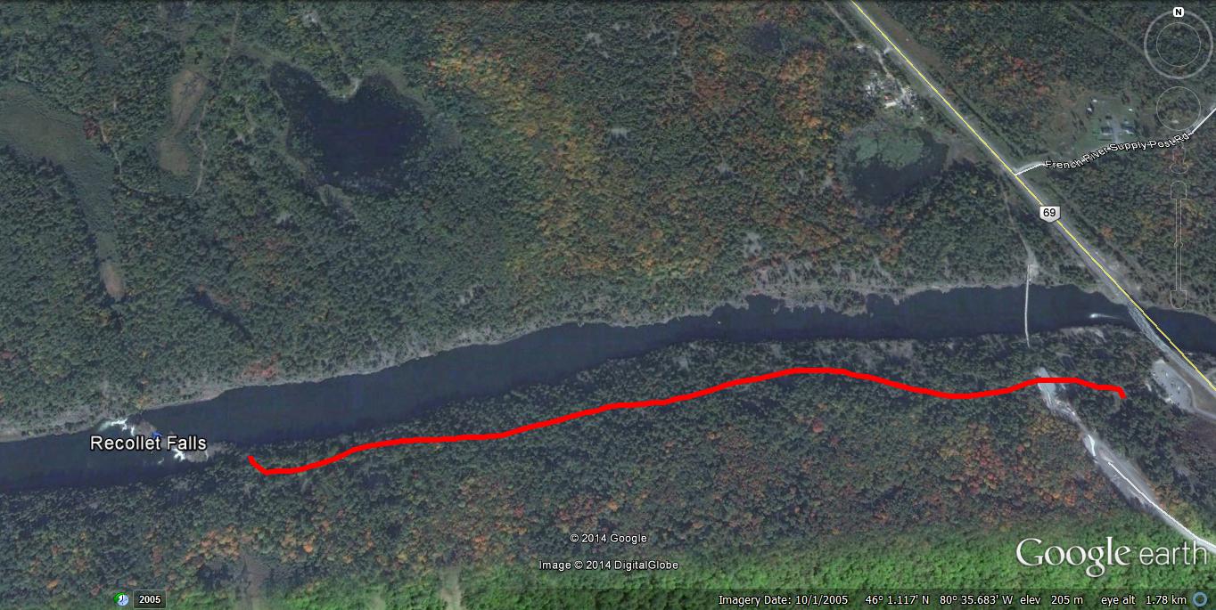 it is the time of year to snowshoe downstream, 1.5 km to the Recollet Falls (WGS 84 17 T E530652 N5095947 or N46° 00.984’ W80° 36.242’), another winter wonderland “photo opp.” You will pick up the non-designated trail at the bridge and head west or downstream, it is an easy trek and there is a historic plaque there commemorating the Recollet Fathers. Access to the suspension bridge and plowed parking lot at the visitor centre (west side) is Highway 69, 80 km (50 miles) south of Sudbury and 95 km (60 miles) north of Parry Sound.
It is recognized that values may compete and change over time, and that heritage may have different meanings for different people. You can close your eyes and imagine what was and take in the moment and value what is. Hold on to the hand rail if need be.